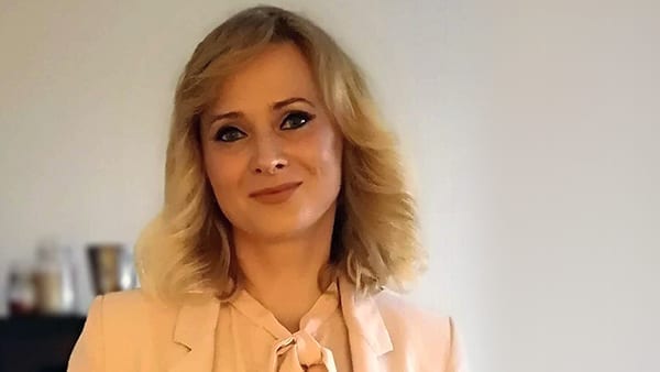
In each edition of Pulse, we publish a short interview with an IOGP colleague or committee member. This month’s interview is with Lucyna (Lucy) Kryla-Straszewska, IOGP Geomatics and Metocean Manager.
Lucy holds a Masters in Physical Oceanography, is a GIS (geographic information system) specialist, and has over 10 years of international project management experience. She joined IOGP in 2012, and manages both the Geomatics and Metocean Committees and over twenty of their global subject matter expert teams.
1. In simple terms: what is Geomatics?
Some 80% of industry data is spatially referenced. Licence boundaries, bathymetry and topography, well locations, infrastructure, and seismic and other subsurface data. It is essential that the positional element of this data is handled correctly to make our industry safer and more efficient, and to properly inform good business decisions.
Geomatics comprises the disciplines of surveying and positioning and geospatial data management. In simple terms, this includes firstly the acquisition and provision of position and survey data above, below, and on the earth, and secondly the management, manipulation, mapping, visualisation and analysis of such ‘spatially referenced’ data.
2. The Geomatics Committee recently celebrated its 15th anniversary. What have been the key achievements of the committee so far?
The Geomatics Committee, formed in 2005 when IOGP absorbed the now retired European Petroleum Survey Group, remains one of the Association’s most active committees. The Committee has delivered and maintains some 40 industry guidelines for geodesy, surveying and positioning, geophysical operations, geoinformation and earth observation, as well as the widely adopted GIS seabed survey data model (SSDM). The Committee is also the custodian of ‘P’ formats used to record marine seismic positioning data and wellbore trajectory data.
2020 has been particularly exciting for us, as we completed development of a significantly updated EPSG GeoRepository. IOGP’s EPSG Geodetic Parameter Dataset, the flagship Geomatics Committee deliverable, actively owned and managed by the Committee for the last 15 years, is the de facto global standard for coordinate reference systems and geodetic parameters. In just three months since the official new EPSG platform release, the site (https://epsg.org/) is accessed by over 1,500 users weekly, while the API ((Application Programming Interface)) ((https://apps.epsg.org/api/), which enables automatic regular pull of EPSG data into applications, gets up to 100,000 calls daily (this means 1 call for data every second).
3. What are the committee’s plans for 2021?
2021 started with a fantastic achievement for the Committee. We have completed one of the most challenging Committee projects by releasing the P7/17 wellbore positioning data exchange format and user guide (Report 483-7, available from IOGP Publications Library.
In mid-2021, the Committee aims to conclude another major project by releasing a new GIGS (Geospatial Integrity of Geoscience Software) online testing platform, via a modernised and simplified framework with targeted, flexible tests, integrated with the EPSG Dataset. GIGS is a robust testing regime providing software developers and users with the means to evaluate an application’s capability to establish and maintain geospatial and geodetic data integrity (read more here).
Also coming in 2021 are new GIS Data Models to complement the SSDM (LSDM, Land Survey Data Model, and OISDM, Offshore Infrastructure Survey Data Model), 4D Seismic Survey Guidelines, a Guidance Note for Geodesy in Angola, a Guidance Note for Seawater Pressure to Depth Conversion, and a Common industry technical specification for fundamental survey sensor calibration and verification.
The Committee will also continue its global advocacy efforts and work with international standards bodies on the development and adoption of standards relating to management of coordinate reference systems.
Despite a turbulent time for the industry, the Geomatics Committee has kept up its momentum and delivering its biggest and most complex projects. I would like to recognise all Committee members for their stupendous commitment to IOGP, specifically thanking the Committee, Subcommittees and Task Forces Chairs.


