The 7th IOGP Industry Day, organised jointly with Statoil at their offices in Stavanger last April, welcomed some 80 participants representing more than 50 different organisations.

The day was inaugurated with the host presentation given by Statoil Vice President of Geophysical Operations, Jan Helgesen. Jan’s excellent talk diverted audience attention from current economic challenges to potential opportunities that can arise from those challenges. He stressed that low oil prices, which Statoil considers to be temporary but cyclic, resulted in revision of the company’s modus operandi, leading to significant increases in efficiency, with Statoil break-even prise reduced as much as 50%, and drilling cost reduced by some 35% over the period of just 4 years. Closing his presentation, Jan said that the North Sea will continue to be a dominant area of interest for Statoil and the company will also further extend their portfolio in the renewable energy sector.
IOGP’s Geomatics Committee Chair Walter Jardine presented the group’s mission and activities. This is one of the most energetic IOGP Committees, he said, comprising industry experts working in the areas of surveying, geodesy, cartography and geospatial data management. It actively maintains more than 35 technical reports, all of which are freely available via the IOGP Bookstore. Walter outlined the Committee’s 2017 programme, highlighting the recent release of Seabed Survey Data Model version 2 and soon-to-be-published Geodesy Guidance Note on Vertical CRSs. For complete information on 2017 Geomatics Committee deliverables see the slides below.
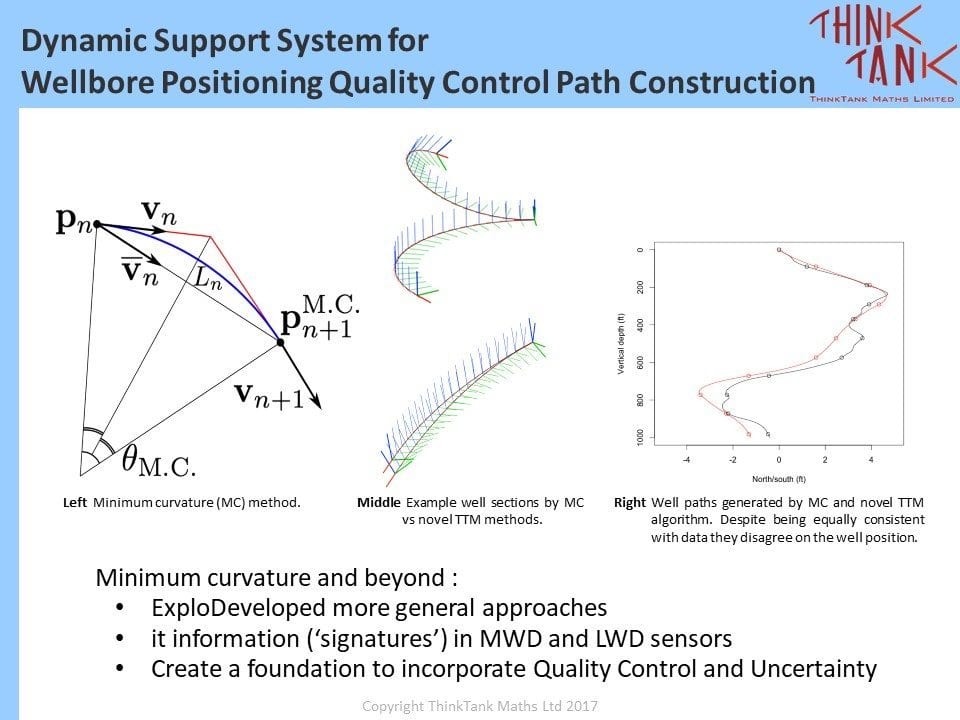
Dr. Cyrille Mathis, Chief Scientific Officer at ThinkTank Maths Ltd, delivered an original perspective on the use of both conventional and unconventional mathematics methods for wellbore positioning quality control. Dr Mathis encouraged the audience to think outside what is considered ‘approved standards’ and warned against oversimplification of highly complex processes.
Roger Lott, the Chair of IOGP Geodesy Subcommittee, opened the next session with a talk on dynamic Coordinate Reference Systems. He introduced the terms ‘static’, ‘dynamic’ and, a hybrid of these two, ‘semi-dynamic’ datums (or more correctly, ‘reference frames’). He went on to describing that relationships between the systems change with time and are mainly caused by continental drift. These differences, growing by small and variable amounts every year, are now becoming noticeable and can be detected by real-time positioning technology, often used by remotely-operated and autonomous vehicles. Roger emphasised that modern geodesy is shifting to embrace the concept of ‘static’, ‘semi-dynamic’ and ‘dynamic’ reference frames. This technical issue remains a priority for the IOGP Geodesy Subcommittee, which is working on developing a Guidance Note on the topic (publication anticipated in 2017). Moreover, a major update of the EPSG data model is planned in 2018, incorporating changes to account for dynamic reference frames.
In the presentation that followed, Frano Cetinic and Tom Rune Lauknes of Globesar demonstrated the use of Remote Sensing Synthetic Aperture Radar technologies for monitoring surface deformation. Growing accessibility to satellite data and their abundance, improved Earth surface coverage, and better data quality were noted. The presenters wrapped up the talk with examples of millimetre to sub-millimetre accuracy now achievable with some forms of Remote Sensing technology.
The afternoon session was opened by Eric Toogood, Diskos Manager at Norwegian Petroleum Directorate, with a presentation about petroleum data management in Norway. Eric outlined legal aspects in relation to data created by oil and gas operators for Norwegian waters, including ownership and confidentiality, and then described how seismic, well and production data gathered from operators are managed within Diskos – the Norwegian National Data Repository. While many in the audience were aware of the large volumes of data being acquired by operators, the exponentially growing numbers of seismic data for Norwegian waters alone, exceeding last year 3.6 Petabyte which is 3.5e+15 Byte, still came as a surprise. In his final slides Eric stressed the importance of standardization and efficient data management. He acknowledged IOGP’s Geomatics Committee for their enduring efforts in promoting good practices within the Geomatics and Geodesy discipline.
Erlend Vågsholm of Kongsberg Seatex presented on advanced solutions for communication between various types of vessels and vehicles during offshore operations. He noted the role of the industry in driving progress by reaching out to the cutting-edge of technology, striving to achieve improved connectivity between different systems both on the surface and subsea, even in extreme water depths and weather conditions.
In the final presentation of the day, Tom Glancy of Statoil provided an insight into future use of Underwater Intervention Drones – UIDs (a collective term proposed for ROVs, AUVs, subsea resident vehicles etc). Tom clarified some basic concepts around UIDs and their typical applications, such as pipeline inspection, light intervention, seabed mapping, environmental surveys and underwater inspection of structures and risers. He envisaged both business and HSSE benefits in these activity domains, and that the need for this technology will continue to grow, leading to greater implementation by Statoil and other operators. Tom’s futuristic vision of UIDs residing on the seabed in their USB docking stations, programmed to perform their tasks in all sea conditions, will certainly be remembered by all who attended the event.
The closing summary was given by Palle Jensen, past Geomatics Committee Chair, who thanked all presenters for their excellent talks and the hosts, Statoil and IOGP, for conducting this inspiring event.
The material presented at the Industry Day 2017 is available here:
- Host presentation, 2017 IOGP Geomatics Industry Day, Jan Helgesen, Statoil
- Geomatics Committee introduction, Walter Jardine, IOGP
- A dynamic support system for wellbore positioning quality control while drilling, Dr. Cyrille Mathis, ThinkTank Maths
- Geodesy on the move, dealing with dynamic coordinate reference systems, Roger Lott, IOGP
- Monitoring surface deformation using satellite data, Frano Cetinic and Tom Rune Lauknes, Globesar
- Petroleum data management in Norway, the National Data Repository – Diskos, Eric Toogood, NPD
- Connectivity and autonomous functions, Erlend Vågsholm, Kongsberg Seatex
- How we think UIDs will be used by Statoil in the future, Tom Glancy, Statoil